2021 Fall Virtual ForumThanks for joining us for a great event! VIEW THE RECORDINGS OF THE EVENT HERE!
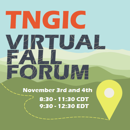
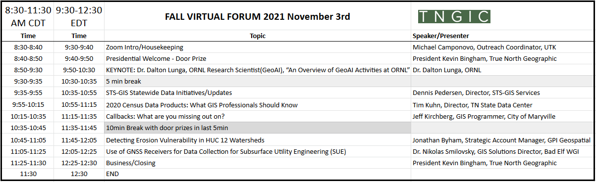
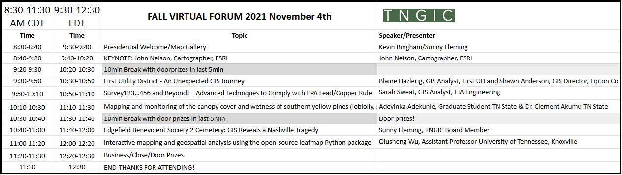
TNGIC IS PROUD TO HOST THE 2021 FALL VIRTUAL FORUMWhen: November 3rd and 4th 8:30 -11:30 CDT, 9:30-12:30 EDT Where: Zoom - info will be posted to the calendar and sent via email Agenda:
Check back frequently for more information as we get closer to the Forum DETAILED AGENDA BELOW TNGIC_Virtual_Fall_Forum20211102_Agenda_forweb.pdf Event RegistrationAttending the TNGIC Fall Forum is free but you do need to register to receive the Zoom details. Log in to your TNGIC account and register here. Keynote SpeakersDr. Dalton Lunga (ORNL) & John Nelson (ESRI)
Dr. Dalton Lunga, ORNL Dalton is currently a research scientist in machine learning driven geospatial image analytics at ORNL. In this role he deploys machine learning and computer vision techniques in high performance computing environments, focusing on creating imagery-based data layers of interest to various societal problems e.g. enable accurate population distribution estimates, damage mapping for national security needs. He currently conducts research and development in machine learning techniques and advanced workflows for handling large volumes of geospatial data. A graduate of Purdue University and former employee at the council for scientific and industrial research in South Africa, Dalton brings both academic and industrial background to ORNL to help lead scientific discovery in geospatial challenges for societal impact.
John Nelson, ESRI John Nelson is a map maker, software experience designer, and writer at Esri creating fringe geographic data, curious web experiences, moderately-educational blogs, and mildly-instructional videos. He works in a small woodshed in Michigan and relishes the opportunity to chat with other map folks.
PresentationsAgenda is posted above! We have many great presentations lined up for the Fall Forum. Virtual Map GalleryShare your work with the geospatial community of Tennessee. We are looking for both static and interactive maps in our virtual map gallery.
Event SponsorshipYour generous support enables us to offer this event to the geospatial community of Tennessee for free. Door prize items may be donated without registering as a sponsor.
Sponsorship Tiers
THANK YOU TO OUR SPONSORS! |