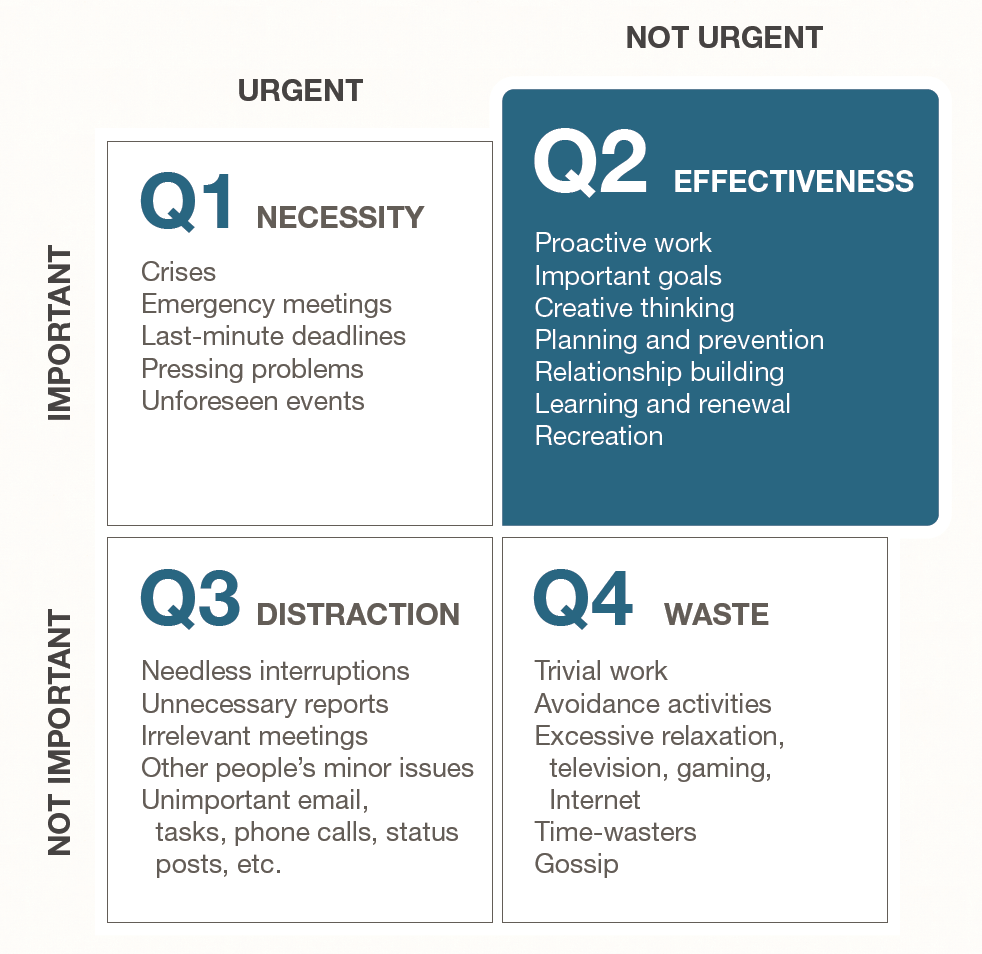
I occasionally hear someone – or myself, for that matter – bemoan the idea that we don’t have time for training and professional development. We often get so caught up in keeping all the day-to-day plates spinning that we often miss the value or importance of keeping up with the industry trends and technology and planning for the future of our organizations. In the very popular book “The 7 Habits of Highly Effective People”, the late Dr. Stephen R. Covey broke down tasks into four quadrants based on 2 axes – Urgency and Importance. Training and professional development, for most of us, falls into Quadrant II – Not Urgent, but Important. Thus, the reason many don’t make time for it.

Source: https://www.franklincovey.com/habit-3/
However, later in “The 7 Habits”, Covey introduces Habit #7: Sharpen the Saw. The opening of the chapter tells a story about someone furiously sawing a tree in the woods. When a passerby asks him why he doesn’t take a break and sharpen the saw, he replies “I don’t have time to sharpen the saw… I’m too busy sawing!” That all sounds great for lumberjacks, you may be thinking, but how does that relate to my geospatial career? Well, in my relatively short 13 years in geospatial technology, I’ve seen things change several times over:
- My first Intro to GIS class used ArcMap 9.2. In those days, ArcCatalog was a standalone program (not a window within ArcGIS Desktop).
- Mapping grade GPS used to be the only economically feasible option for data collection—period—let alone the high accuracy products that are now much more affordable. Never mind the fact that the accuracy of those units is similar to the accuracy of the cell phones we all carry in our pockets today.
- In graduate school, I spent a semester learning Visual Basic, only to have the computer labs updated to ArcMap 10.0 over winter break. For those familiar with that change, the programming language of ESRI switched to Python at that release.
- Anyone remember ArcGIS Viewer for Flex?
These are just a few examples, but the point is, that technology is constantly changing, and as GIS professionals, we need to make an honest effort to keep up with the trends in technology and prepare ourselves, as well as our departments and users for change. It’s much easier to justify added cost or to explain to end users why a workflow needs to change when we have all the facts and have exhausted all other options before making a request. Keeping up with the technology is important when upgrading software that integrates with other platforms. As more and more systems need to be able to interface, version compatibility is an important consideration before scheduling upgrades.
Tips to stay sharp:
- Network – GIS shops are typically small, so networking outside of your organization provides fresh insight and different perspectives that may help spark new ideas for projects or datasets.
- Community involvement – Sometimes teaching is the best way to reinforce what we've learned. Look for volunteer opportunities for conservation or scouting groups that may be interested in learning about GPS and data collection.
- Webinars – Another low-cost opportunity to see what others are doing.
- Training – Both in-person and online training is vital to develop new skills. Maybe setting aside 20-30 minutes a week to learn a new scripting language is something you want to commit to over the next year. Alternatively, there may be an immersive 3-day onsite training that could take a particular skillset to the next level of proficiency. Be creative depending on your work situation and time/financial resources available.
- Professional organizations – A good organization should offer all of the above, but acts as a central hub for training, networking, volunteering. Continuing education for certifications is also achieved through membership and service of an organization.
I’ve put each of these into practice at various stages of my career. When I was applying to jobs coming out of grad school, I would use ESRI’s online training to learn about specialized concepts that were not taught in the classroom (topology, network analysis, parcel fabrics) to have a working knowledge before going into an interview. More recently, I found out one of the improvements implemented in the latest Enterprise release will save my organization a lot of time and resources if we upgrade the software instead of pursuing a customized SQL-based solution. Add to that the social, technical support, and collaboration opportunities that accompany a group of fellow geospatial practitioners, such as those in TNGIC, and you are well on your way to developing a successful personal development path.
